January 2026.

Franklinton, also known as “The Bottoms,” is a neighborhood of Columbus that was actually founded as its own town and pre-dates the city. It has some of the oldest buildings in Columbus. However, due to its location in an area that frequently floods, it has been a working-class neighborhood for much of its history. Most of its historic Broad Street corridor was demolished for factories in the mid-19th century, and today, the eastern ends of the neighborhood are rapidly gentrifying.
Franklinton is located on the near west side of Columbus, Ohio. It is bordered by the Scioto River, the Arena District, and Grandview to the north, I-70 and southwest Columbus to the south, the river again and downtown to the east, and I-70 and Hilltop to the west.
History
Franklinton was settled in 1797, six years before Ohio even became a state. Its first resident was Lucas Sullivant (whose name now belongs to a street in Franklinton known for things…ahem…other than Ohio history), who worked for the state of Virginia to survey their Virginia Military District in Ohio. After his work was complete, Sullivant returned to Ohio and platted 220 lots. He named this settlement Franklinton, after Benjamin Franklin. Franklinton flooded for the first time just a year later, and Sullivant relocated it further west from the Scioto River’s edge. This flooding eventually earned Franklinton its nickname of “The Bottoms.”

Franklinton’s original layout. (Wikimedia)
Franklinton’s early growth was spurred by Sullivant’s offering of free land on Gift Street. Structures in the town included a courthouse, a house to impress his wife Sarah, and a church, all of which were built out of brick and glass from Philadelphia. The first bridge across the Scioto was also built at this time. In 1803, Franklin County was created from land that formerly belonged to Ross County, and Franklinton was named the county seat. The War of 1812 brought further growth to the town, as general and future president William Henry Harrison used it as a staging point for the Army of the Northwest.
The founding of Columbus in 1812 was a blessing and curse for Franklinton. With the city of Columbus’s construction, Franklinton’s population continued to climb, but so did Columbus’s. Franklinton was supplanted as the county seat by Columbus in 1824, and it was annexed into the city in the 19th century. (So many sources give different dates--I’ve seen as early as 1837 and as late as 1959.) As of 1840, it had 394 residents.

A view of east Franklinton in 1923, with Central High School under construction. (Wikimedia)
With the Industrial Revolution, Franklinton shifted away from an agrarian community to an urban one like Columbus. Railroads, such as the Columbus & Xenia Railroad in 1850, drew industry and more residents to work at these newly built factories. Most of the industrial buildings were on the east side of Franklinton, which was prone to flooding. A levee system was built in 1889, and many of Franklinton’s homes date to after that period.

Flood damage in 1913. The tower in the background belongs to Engine House No. 6. (Columbus Metropolitan Library)
A major event in Franklinton’s history was the Great Flood of 1913. Heavy rains caused the Scioto to rise so much that it destroyed the wooden levees, and the water level reached up to 17 feet above normal. Most residents fled to the Hilltop, but 93 people died in the flood and 20,000 became homeless, and every single bridge near downtown was destroyed.
The mid-20th century began Franklinton’s decline, as it reached its peak of 26,500 people in 1950. Another major flood occurred in 1959, which was exacerbated by the January frozen soil. The construction of OH-315 cut Franklinton in half and demolished several houses, while creating a de facto barrier between the east and west sides of the neighborhood. Additionally, I-70’s construction further sealed off the south and west sides. In 1983, FEMA declared that Franklinton was in a floodplain, meaning new construction had to meet more stringent criteria to be insured. This resulted in a lack of development and continued population decline. Its population has since shrunk to about ⅓ of its 1950 size.
In 2004, a new floodwall was completed, which allowed the city to resume constructing buildings as normal. This began the slow march of gentrification in Franklinton, as the east side began to have dilapidated buildings demolished and replaced with upmarket apartment buildings. Between 2009 and 2011, three housing projects on the southeast side of the neighborhood were demolished, and their sites are now 5-over-1 apartments. The city of Columbus is trying to redevelop the eastern side and bring it to a Short North-esque condition.
Photos
Franklinton Post Office

This unassuming, slightly deteriorated house is the Franklinton Post Office, which holds the distinction of being the oldest building in Columbus on its original site. It was originally a log cabin built by settler David Deardurff, who came from Pennsylvania with his father Abraham in 1798 and was a recipient of the land that Lucas Sullivant offered for free on Gift Street. Upon arriving, David and his father lived across from this house at the southwest corner of Gift and Culbertson.
The post office itself was David Deardurff’s own house and was built in 1807, being the first post office in Franklinton. The nearest post office was in Chillicothe, about 50 miles south of Columbus, and the mailman (a 13-year-old boy named Andrew McElvain) had to ride three days each way to pick up and deliver mail. The post office closed in 1834.
The lean-to addition on the east end is not original and was built in the 1860s. The windows and siding are also antique but not original. The house remained in use as a residence until the 1950s.

The house in 1972. (NRHP listing)
The house was purchased by the Sells family (presumably descendants of Peter Sells) in 1962, preventing its demolition and conversion into a parking lot. As of 1973, they planned to restore the house to its earliest condition, which would involve removing the addition and the exterior shingles. However, the building was still threatened by the city of Columbus due to structural deterioration. In 1973, it was listed on the National Register of Historic Places. It was listed on the Columbus Register of Historic Properties in 2001, though the house was still abandoned and decaying.

Note the fading paint and peeling shingles above the glass panel.
Google Maps shows sporadic exterior renovation work beginning in 2009, and by 2017 the building appeared to be completely restored. Interestingly, glass panels were installed on the facade to highlight the log cabin frame beneath. However, the house still seems to be abandoned, and these glass panels were actually obscured by 2020. Why this happened is beyond me. It’s unclear if any future use will come of the building.
Harrison House (General William Henry Harrison Headquarters)

The house during its vacancy. (Ohio Exploration Society)
This brick house on Broad Street next to Holy Family Church was built in 1807 by Jacob Oberdier, one of Franklinton’s earliest settlers. It is an example of Federal architecture, which usually isn’t part of this blog’s scope, but Columbus has very few buildings in that style.
The house is most notable for its brief use as a headquarters by William Henry Harrison, as Franklinton was a staging point for his army during the War of 1812. He used it for only a brief period, the winter of 1813-1814, and it is unclear how he came into possession of the house. However, it is the only existing building in Ohio connected to him.

The rear of the hotel in 1972. (NRHP listing)
The house was occupied by the Kuhn family beginning in 1865, and the last family member died in 1972. As a result, the house was at risk of demolition in favor of a used car lot. It was listed on the National Register of Historic Places that year. Luckily, the house was purchased by the city of Columbus in 1980, and it has since been restored by the Columbus Historical Society, which operates it as a museum today.
Here is the house today:

Bellows School (Bellows Avenue Elementary School)

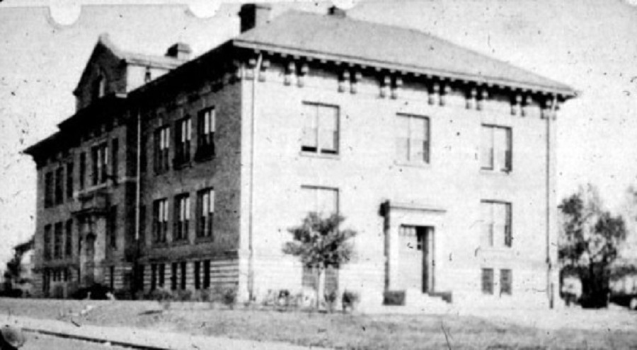
Blurry historic photo of the school. (All Columbus Data)
The Bellows School is visible from OH-315 and somehow has survived past the 1960s. It was designed by Columbus Public Schools architect David Riebel and built by George Bellows Sr. (who the school and street are named after). The school was completed in 1905 and is an example of Renaissance Revival architecture.

Aerial view of the school during construction of the interstate. (Columbus Metropolitan Library)
The construction of OH-315 in the 1950s cut off access to the school from the east and resulted in a busy highway running right next to it. Despite this, the school stubbornly held on until 1977, when it was finally closed. It has remained vacant since, and it was sold to the city in 1984.
In the long-term, the Bellows School is slated for demolition for the construction of new highway ramps. Despite this, it was purchased in 2014 by a developer, who sought to convert it into apartments and build townhouses nearby. His logic was that the highway project would take decades to proceed, and no money was yet budgeted by the highway department. Combined with a proposed historic designation by the city or federal government, the goal is to make purchase of the site more difficult and expensive.
It has been under renovation since, and despite such a long period of restoration, notable progress has been made. There were workers on-site when I visited, and new windows have been added to the second floor. Its future is unclear, since some sources suggest that the highway construction will occur within a couple decades.

You can see the work trucks on the west side--it has taken a while, but work is still making progress. I think the new windows have been boarded up to deter vandalism.

Highlights of this design include the large cornice and fanciful entrance portal. It is a standard Renaissance Revival design with lots of fun ornamentation.

For its age, this stone detailing is actually in pretty good condition. There seems to be minor wear on the cornice, but that’s pretty much it.

Westside Boys & Girls Club (West Market)

Engraving of the building circa 1889. Note the missing cupola on top of the tower. (Local Wiki)
You’ve probably heard of North Market and maybe the new East Market in Franklin Park…well, there was a West Market in Franklinton too. It was built in the Romanesque Revival style by Kremer & Hart and opened in 1889. It had 36 market stalls, a meeting hall and stage on the second floor, and committee rooms. It was remodeled in 1908 to add more vendor space. Its role as a market and community center made it an icon of the neighborhood, and it was remodeled again in 1933 to better accommodate sports such as basketball.
By the 1940s, however, the building was becoming run-down and threatened with demolition. The market only operated for a period of about 50 years, and it was converted to the Westside Boys Club in 1948. Girls were allowed to join in 1970, and the name was changed to Westside Boys & Girls Club in 1990. It seems like the organization built two additions, one in the mid-20th century and the other in the 1990s. Though the building was the largest that the Boys & Girls Club owned, they abandoned it in 2016 due to the area’s low density, and it has remained vacant since.

The brick exterior has been stuccoed and painted white, much of the remaining stonework is now painted, and the windows have been replaced. The overall form is still apparent, however.
Column and lintels above the doors:

The tower:

Franklinton’s redevelopment is harming historic buildings such as this one, dilapidated as they are. The people that once lived in the neighborhood are being pushed out as apartments they cannot afford are being built. It is one thing to revitalize a neighborhood, but demolishing housing projects for the construction of luxury apartments is gentrification, plain and simple.
Sources:
Architecture: Columbus by Robert Samuelson
Columbus Neighborhoods by Tom Betti
https://en.wikipedia.org/wiki/Franklinton_(Columbus,_Ohio)
https://en.wikipedia.org/wiki/Great_Flood_of_1913_in_Columbus,_Ohio
https://digital-collections.columbuslibrary.org/digital/collection/ohio/id/13701
https://catalog.archives.gov/id/71988619
https://catalog.archives.gov/id/71988611
https://www.franklintonhistoricalsociety.org/pioneer-homes
https://www.columbushistory.org/harrisonhouseandsullivantlandoffice
https://www.ohioexploration.com/structures/harrisonhouse/
https://digital-collections.columbuslibrary.org/digital/collection/p16802coll28/id/140876/rec/8
https://columbuslandmarks.org/2015-most-endangered-buildings/#bellows
https://allcolumbusdata.com/wp-content/uploads/2019/10/bellowsavenue1905.jpg
https://columbusunderground.com/plan-for-bellows-school-site-to-be-heard-by-commission-bw1/
https://en.wikipedia.org/wiki/Bellows_School
No comments:
Post a Comment